Live ocean source gateway
Weather alerts, weather observations, water-level context, buoy telemetry, harbour data, protected-area context, and provider-quality metadata where connected.
Tide Architect brings ocean, weather, harbour, habitat, fishery, source-status, and operating assumptions into one visual decision-support environment. It is built for the working coast: captains, associations, harbour managers, researchers, regulators, processors, and coastal planners.
Marine and fisheries decisions depend on too many disconnected sources: weather, tides, buoy observations, public fishery context, harbour locations, protected areas, habitat plans, vessel operating assumptions, and local knowledge. Tide Architect makes those signals visible without pretending every source has the same role or confidence.
Design principle
The platform labels source roles and states so users can distinguish live evidence, context-only data, fallback assumptions, planned integrations, missing fields, and unmapped routes.
Tide Architect is not just a map. It is a source-backed planning surface that connects marine conditions, fishery context, habitat tools, and decision support.
Weather alerts, weather observations, water-level context, buoy telemetry, harbour data, protected-area context, and provider-quality metadata where connected.
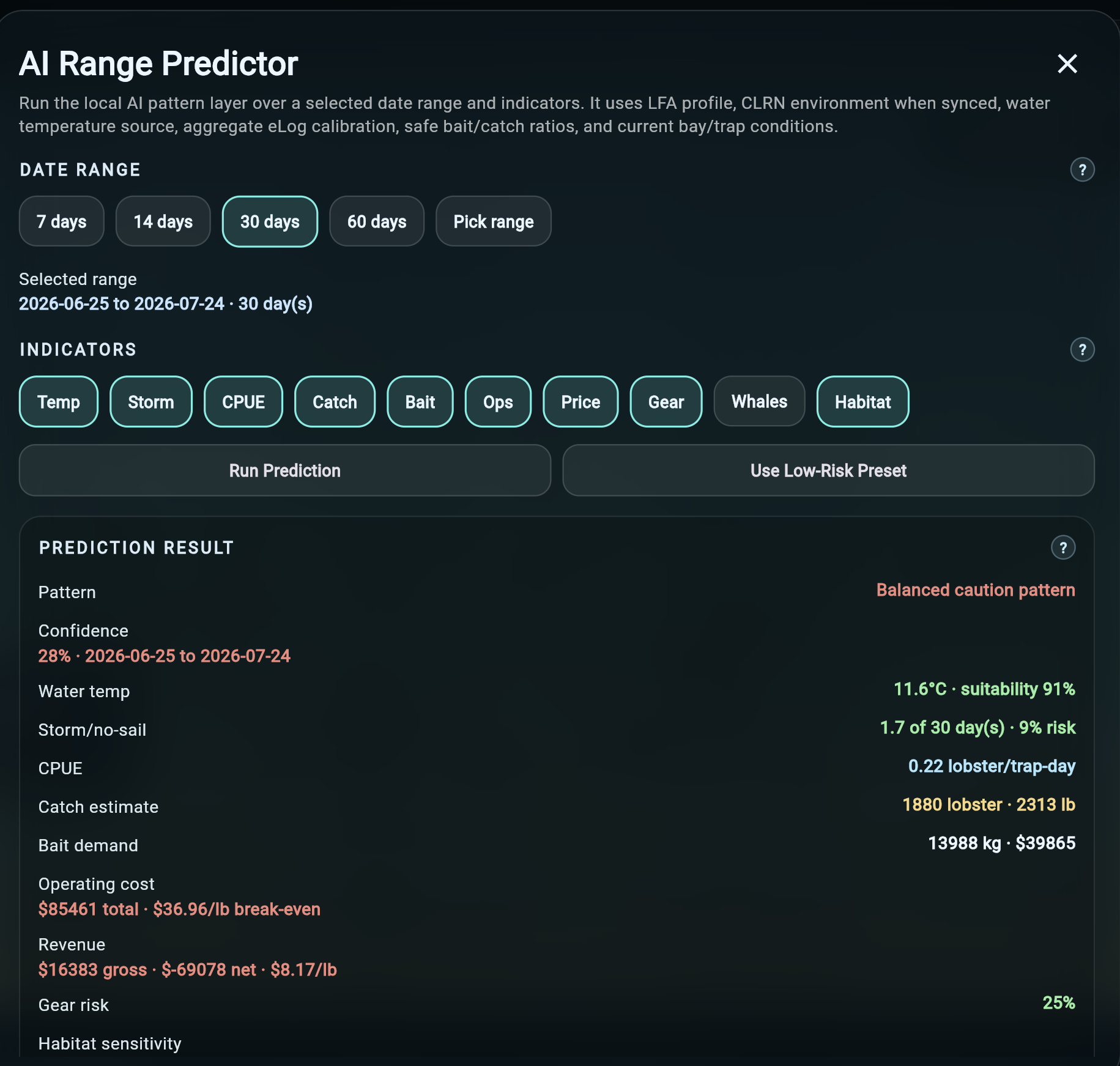
LFA selection, species focus, trip economics, vessel cost assumptions, safe-ratio logic, operating indicators, and public baseline context.
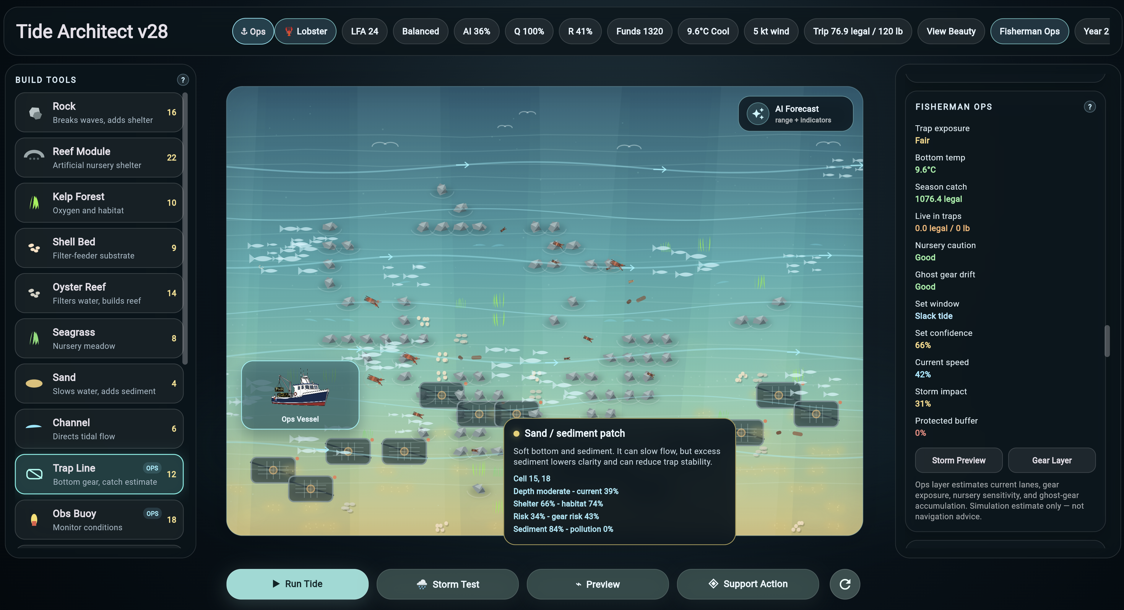
Kelp, reef modules, shell beds, oyster reefs, seagrass, trap lines, buoys, no-set zones, channels, shelter structures, and coastal build planning.
Provider labels, quality notes, source confidence, missing-field visibility, route status, and model-use explanations for more honest planning.
Decision-support views that summarize conditions, assumptions, missing evidence, operating risk, and next questions for human review.
Future calibration can use aggregate fishing knowledge without exposing private vessel, buyer, trap, trip, or catch records.
That difference matters in fisheries and coastal planning because landings, CPUE, abundance, effort, weather, habitat, harbour conditions, and catch prediction are not interchangeable.
Weather, water level, current, surface temperature, wave context, and related marine condition evidence.
Fishery summaries, landings context, sustainability notes, LFA information, and source-specific caveats.
Habitat modules, trap lines, observation buoys, protected zones, operating assumptions, and scenario planning.
AI-assisted indicators and briefings remain supporting evidence for human review, not automatic operational orders.
Use shared source context to support members, understand operating conditions, and explain decisions.
Review harbour sensitivity, nearby conditions, operational risks, and planning constraints.
Connect environmental observations, public datasets, habitat structures, and source-quality notes.
Model habitat, restoration, protected zones, and operational impacts with transparent source caveats.
Socilogica advantage
Tide Architect shows that Socilogica can build beyond forms and portals into source-backed intelligence systems where credibility, transparency, and operator trust matter.
Explore fisheriesWe can start with a source registry, planning map, dashboard, or decision-support slice and build toward a larger operating picture.